The best marine navigation software for PC is TimeZero Navigator. It offers advanced chart plotting and real-time weather updates.
TimeZero Navigator stands out due to its comprehensive features, user-friendly interface, and reliable performance. This software supports various chart formats, including raster and vector charts, ensuring navigators have the most accurate information at their fingertips. Real-time weather updates, tide predictions, and route planning tools enhance safety and efficiency on the water.
The integration with AIS (Automatic Identification System) allows for tracking nearby vessels, reducing collision risks. With frequent updates and excellent customer support, TimeZero Navigator remains a top choice for marine navigation. Whether for professional or recreational use, this software meets the needs of modern mariners.
Charting The Digital Seas
Today’s sailors rely on modern technology to navigate the vast oceans. Marine navigation software for PC has revolutionized the way we chart our courses. This software offers precision, ease, and a wealth of information at our fingertips. Let’s dive into the benefits and the shift towards digital navigation.
The Shift To Digital Navigation
Traditional paper charts were once essential for marine navigation. They provided detailed maps of the seas. But they had limitations, such as the need for constant updates and physical storage space.
With the advent of digital navigation software, sailors can now access up-to-date charts. These charts are dynamic and can be easily updated. Digital tools offer features like real-time tracking and weather updates, making navigation safer and more efficient.
Benefits Of Pc-based Navigation Software
Using PC-based navigation software comes with numerous benefits. Here are some key advantages:
- Real-time Updates: Get the latest chart updates and weather information instantly.
- Enhanced Accuracy: Digital tools provide precise positioning and detailed maps.
- Ease of Use: User-friendly interfaces make navigation simple, even for beginners.
- Cost-Effective: No need to buy new paper charts; updates are often free or cheaper.
- Integration: Sync with other devices like GPS and tablets for a seamless experience.
Here’s a quick comparison of traditional and digital navigation:
| Feature | Traditional Navigation | Digital Navigation |
|---|---|---|
| Updates | Manual | Automatic |
| Accuracy | Moderate | High |
| Storage | Physical space needed | Digital storage |
| Cost | High for new charts | Lower with software |
Switching to PC-based navigation software opens up a world of possibilities. It’s a game-changer for modern sailors.
Credit: www.discoverboating.com
Key Features To Look For
When choosing the best marine navigation software for PC, it is essential to consider several key features. These features ensure you have a reliable and efficient tool for safe and smooth sailing. Below are the critical aspects to look for:
Accurate Charting Tools
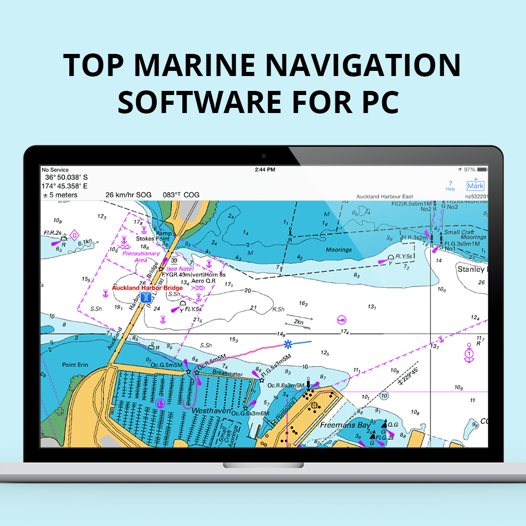
One of the most crucial features is accurate charting tools. The software must provide detailed and up-to-date nautical charts. Charts should include essential information like water depths, hazards, and coastal features. Look for software that supports vector and raster charts for better versatility.
Some software also allows users to overlay additional data on charts. This can include fishing zones, marine protected areas, and more. Accurate charting tools help in precise navigation and avoiding potential dangers.
Real-time Weather Updates
Real-time weather updates are vital for safe maritime navigation. The software should provide current weather conditions and forecasts. This includes wind speed, wave height, and precipitation information.
Weather updates should be integrated seamlessly into the navigation interface. This helps in making informed decisions quickly. Some software also offers alerts for severe weather conditions, which can be lifesaving.
Route Planning And Management
Effective route planning and management features are essential. The software should allow users to plan routes by setting waypoints. Users can adjust these routes based on real-time conditions.
Route management tools should include options for saving and modifying routes. Look for features like automatic route optimization and fuel consumption estimates. This ensures efficient and cost-effective navigation.
| Key Feature | Description |
|---|---|
| Accurate Charting Tools | Provides detailed, up-to-date nautical charts with essential information. |
| Real-Time Weather Updates | Offers current weather conditions, forecasts, and severe weather alerts. |
| Route Planning and Management | Allows users to plan, save, and modify routes efficiently. |
Top Marine Navigation Software For Pc
Sailing can be thrilling with the right tools. Marine navigation software helps sailors navigate safely. It offers features like route planning, weather updates, and real-time tracking. Let’s explore the top choices for PC users.
Popular Choices Among Sailors
Many sailors prefer certain software for their reliability and features. Here are some popular options:
- Navionics – Known for detailed charts and user-friendly interface.
- OpenCPN – Free, open-source, and highly customizable.
- TimeZero Navigator – Offers 3D charts and advanced weather forecasts.
- Rose Point Coastal Explorer – Provides comprehensive route planning tools.
Comparative Analysis Of Leading Software
Comparing the features helps in choosing the best software. Below is a table summarizing the key features of each software:
| Software | Price | Main Features | Compatibility |
|---|---|---|---|
| Navionics | Subscription-based | Detailed charts, user-friendly interface | Windows, Mac |
| OpenCPN | Free | Highly customizable, open-source | Windows, Linux, Mac |
| TimeZero Navigator | Paid | 3D charts, advanced weather forecasts | Windows |
| Rose Point Coastal Explorer | Paid | Comprehensive route planning | Windows |
Compatibility And Integration
Compatibility and integration are crucial for marine navigation software. Ensuring your software works seamlessly with your hardware ensures efficient operations. This section covers two key aspects: Ensuring Software-Hardware Synergy and Cross-Platform Functionality.
Ensuring Software-hardware Synergy
Marine navigation software must work well with your devices. This includes GPS, radar, and autopilot systems. Compatibility ensures accurate data and smooth operations.
Check if the software supports your hardware brands and models. Some software offers extensive compatibility lists. Others provide limited support.
Here’s a quick table for reference:
| Software | Supported Devices | Notes |
|---|---|---|
| Navionics | Garmin, Raymarine | Excellent charting features |
| TimeZero | Furuno, Simrad | Advanced 3D mapping |
| Rose Point Coastal Explorer | Various GPS units | Great for detailed planning |
Cross-platform Functionality
Your marine navigation software should work across different platforms. This includes Windows, Mac, and mobile devices. Cross-platform functionality ensures you can access your charts anywhere.
Look for software that offers cloud syncing. This feature keeps your data updated across all devices. It also provides a backup in case of hardware failure.
Here are some examples of cross-platform compatibility:
- Navionics: Available on Windows, Mac, iOS, and Android.
- TimeZero: Offers apps for both desktop and mobile platforms.
- OpenCPN: Compatible with Windows, Mac, Linux, and Android.
Ensuring cross-platform support maximizes flexibility and convenience.
User Experience And Interface
Choosing the right marine navigation software for your PC requires careful consideration. A great user experience and intuitive interface play a crucial role. These factors ensure you can navigate the software effortlessly. They also enhance your overall sailing experience.
Ease Of Use
A user-friendly interface is essential for effective marine navigation. Ease of use means you can quickly understand and operate the software. The best marine navigation software should offer:
- Simple and clean design
- Clear and readable charts
- Easy-to-find tools and features
- Quick access to important functions
These aspects make navigation straightforward, reducing the learning curve. This is especially important for beginners. Even experienced sailors benefit from a smooth and efficient interface.
Customization Options
Every sailor has unique needs. Therefore, customization options are vital in marine navigation software. Customization allows you to tailor the software to your preferences. The best programs offer:
- Adjustable chart display settings
- Customizable toolbars and menus
- Personalized route planning features
- Options to save and recall settings
These features ensure the software adapts to your specific needs. They provide a more personalized and efficient navigation experience.
| Feature | Benefits |
|---|---|
| Simple Design | Reduces confusion, enhances focus |
| Readable Charts | Improves situational awareness |
| Adjustable Settings | Provides a tailored experience |
| Custom Toolbars | Quick access to frequently used tools |
In summary, focusing on user experience and interface ensures smooth sailing. Easy-to-use and customizable software can make all the difference.
Support And Resources
Finding the best marine navigation software for PC can be challenging. One critical aspect to consider is the support and resources that come with the software. Having robust support ensures smooth sailing, literally and figuratively.
Access To Customer Service
Having reliable customer service is essential for any marine navigation software. Look for software providers that offer multiple ways to contact support. These can include:
- Phone
- Live chat
Response time is crucial. A good service should address issues quickly. Check user reviews to gauge the effectiveness of their customer service.
Community And Tutorial Availability
A strong user community can be invaluable. Many marine navigation software solutions have forums and user groups. These communities provide tips, tricks, and troubleshooting advice.
In addition, look for software that offers comprehensive tutorials. Tutorials can come in various formats:
- Video tutorials
- Step-by-step guides
- Webinars
These resources help users get the most out of their software. They also reduce the learning curve, especially for beginners.
Summary Table Of Support And Resources
| Feature | Description |
|---|---|
| Customer Service | Support through email, phone, and live chat. |
| Community | Active user forums and groups for sharing knowledge. |
| Tutorials | Video tutorials, step-by-step guides, and webinars. |
Safety Features And Considerations
Choosing the best marine navigation software for your PC is crucial. Safety features play a vital role in ensuring a secure journey. Let’s dive into the essential safety features to consider.
Emergency Protocols
Emergency protocols are essential. They provide quick access to help. Here are some key features:
- Automatic Distress Signals: Sends alerts to nearby vessels.
- Man Overboard Function: Marks the location instantly.
- Weather Updates: Provides real-time weather alerts.
These features help in emergencies. They ensure timely responses and assistance.
Backup Systems And Redundancy
Backup systems are critical for navigation software. They ensure continuous operation. Consider these redundancy features:
| Feature | Description |
|---|---|
| Offline Maps | Access maps without an internet connection. |
| Data Backup | Stores voyage data securely. |
| Secondary Power Source | Ensures software runs if the main power fails. |
These backup systems provide reliability. They ensure your navigation remains uninterrupted.

Credit: navigationlaptops.com
Cost And Value
Choosing the best marine navigation software for PC involves understanding cost and value. This ensures that you get the most bang for your buck. Let’s delve into the pricing models and long-term value of marine navigation software.
Understanding Pricing Models
Marine navigation software often comes with different pricing models. These models can affect your overall costs and benefits.
- Subscription-based: You pay a monthly or yearly fee. This model often includes regular updates and support.
- One-time purchase: You pay a single fee upfront. This model might not include updates.
- Freemium: Basic features are free. You pay for advanced features.
Each model has its pros and cons. Subscriptions can be costly over time. One-time purchases might lack future updates. Freemium versions can be limited in features.
Evaluating Long-term Value
Long-term value is crucial in choosing the right software. Here are some factors to consider:
| Factor | Consideration |
|---|---|
| Updates | Regular updates ensure the software remains current. |
| Support | Good customer support can save you time and hassle. |
| Features | Advanced features can enhance your navigation experience. |
| Compatibility | Ensure the software works with your current hardware. |
Evaluate these factors to determine the best value. A subscription might be more valuable with regular updates. A one-time purchase could be better for budget-conscious users. Freemium versions offer a balance but may require upgrades.
Choosing the best marine navigation software for PC is about balancing cost and value. Consider both pricing models and long-term value to make an informed decision.
Future Of Marine Navigation Software
The future of marine navigation software is incredibly promising. With rapid advancements, the marine industry is experiencing a revolution. Navigators can now rely on more accurate, efficient, and user-friendly tools. Cutting-edge technologies are making navigation safer and easier. Below, we explore the emerging technologies and predict future advancements in marine navigation software.
Emerging Technologies
New technologies are transforming marine navigation software. These advancements offer improved safety, accuracy, and user experience.
- Artificial Intelligence (AI): AI can predict weather patterns and optimize routes.
- Augmented Reality (AR): AR overlays digital information onto the real-world view, enhancing situational awareness.
- Internet of Things (IoT): IoT connects various devices, providing real-time data for better decision-making.
- Blockchain Technology: Blockchain ensures secure and transparent transactions and data storage.
Predictions For Advancements
The future holds many exciting advancements for marine navigation software. Here are some predictions:
- Enhanced Real-Time Data: Future software will provide more precise, real-time data, enhancing navigational accuracy.
- Autonomous Vessels: Self-navigating ships will become more common, reducing human error and increasing efficiency.
- Better Integration: Software will integrate seamlessly with other marine technologies, creating a unified system.
- Environmental Monitoring: Enhanced environmental data will help in planning eco-friendly routes.
Below is a table summarizing the key emerging technologies and their benefits:
| Technology | Benefits |
|---|---|
| Artificial Intelligence (AI) | Predicts weather, optimizes routes |
| Augmented Reality (AR) | Enhances situational awareness |
| Internet of Things (IoT) | Provides real-time data |
| Blockchain | Secures transactions, data storage |
Making The Decision
Choosing the best marine navigation software for your PC can be challenging. With many options available, it’s important to consider various factors. This section will guide you through making an informed decision by looking at trial periods, demos, and user reviews.
Trial Periods And Demos
Many software providers offer trial periods and demos. These allow you to test the software before committing. During the trial, you can explore features and see how user-friendly the interface is.
Here are some questions to consider during your trial:
- Is the software easy to navigate?
- Does it offer the features you need?
- How well does it integrate with your existing equipment?
User Reviews And Testimonials
User reviews and testimonials are invaluable. They provide real-world insights into the software’s performance. Look for reviews on forums, websites, and social media.
Consider these aspects when reading reviews:
- Overall satisfaction
- Ease of use
- Customer support
- Reliability and accuracy
Below is a table summarizing some popular marine navigation software and their trial periods:
| Software | Trial Period | User Rating |
|---|---|---|
| Navionics | 2 Weeks | 4.5/5 |
| TimeZero | 1 Month | 4.2/5 |
| OpenCPN | Free | 4.0/5 |
Using these tips and tools, you can choose the best marine navigation software for your PC.
Credit: fixthephoto.com
Frequently Asked Questions
What’s The Best Marine Navigation System?
The best marine navigation system is the Garmin GPSMAP series. It offers precise navigation, user-friendly interface, and advanced features.
Is There A Marine Version Of Google Maps?
Yes, there is a marine version of Google Maps. It’s called Google Earth, featuring marine charts and ocean data.
Is Savvy Navvy Better Than Navionics?
Both Savvy Navvy and Navionics have their strengths. Savvy Navvy offers user-friendly navigation with route planning. Navionics provides detailed charts and advanced features. Choose based on your needs.
Is There A Free Version Of Navionics?
Navionics offers a free version with limited features. You can download it from the App Store or Google Play.
Conclusion
Choosing the best marine navigation software for your PC ensures safe and efficient sailing. Each option offers unique features tailored to different needs. Evaluate your specific requirements and budget before making a decision. Investing in reliable software can significantly enhance your maritime experience.
Happy sailing with the right tools at your helm!

